
East Multnomah 토양 및 수질 보존 지구 serves all of Multnomah County east of the Willamette River. In general terms, the borders of our District are defined by the Columbia River to the North, the Multnomah County-Clackamas County line to the South, the Multnomah County-Hood River County line to the East and the Willamette River to the West.
EMSWCD’s service area is divided into three zones. All board positions are elected by all residents of the District regardless of the zone they live in. One board member represents each zone and there are two At-Large positions.
The areas and boundaries of these zones are described below.
-
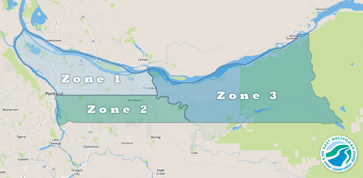
- The East Multnomah Soil and Water Conservation District is divided into three zones, which are shown here.
1 지역
 구역 1은 Willamette River에서 Sandy River까지 Willamette Base Line(Willamette Meridian) 북쪽에 위치한 Multnomah 카운티로 구성됩니다.
- 북쪽: 오리건주 멀트노마 카운티와 워싱턴주 클라크 카운티를 구분하는 경계선을 따라 흐르는 컬럼비아 강
- 남쪽: Willamette Base Line (T.1N – T.1S township line) Stark Street는 Willamette Base Line을 따라 거의 Sandy River까지 이어집니다. 스타크 스트리트는 강의 바로 서쪽 남쪽으로 휘어져 있습니다. 기준선은 동쪽으로 계속됩니다. 구역 경계는 기준선입니다.
- 동쪽: Sandy River의 주요 수로
- 서쪽 : 윌라멧 강(Willamette River)의 주요 수로
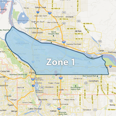
2 지역
 구역 2는 Willamette River에서 Sandy River까지 Willamette Base Line 남쪽에 위치한 Multnomah 카운티 전체를 포함합니다.
- 북쪽: Willamette Base Line(T.1N – T.1S 타운십 라인)
- 남쪽: Multnomah 카운티 – Clackamas 카운티 경계선(단면선)
- 동쪽: Sandy River의 주요 수로
- 서쪽 : Willamette River의 주요 수로인 Ross Island가 이 구역에 포함됩니다.
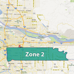
3 지역
(모든 원본 지도 이미지는 © Google 2013입니다.)
구역 3은 Sandy 강 동쪽에 위치한 Multnomah 카운티 전체를 포함합니다.
- 북쪽: 오리건주 멀트노마 카운티와 워싱턴주 클라크 카운티 사이를 잇는 컬럼비아 강
- 남쪽: Multnomah County-Clackamas County 경계선(단면선)
- 동쪽: 멀트노마 카운티-후드리버 카운티 경계선
- 서쪽 : Sandy River의 주요 수로